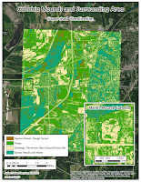
In module 9 we classified data gathered with remote sensing techniques in two ways: unsupervised and supervised.
In unsupervised classification, we let the software classify pixels into a number of predetermined classes. The downside of this type of classification is that number of categories can overlap. Also some vastly different features may be assigned into the same category, because the shade and tone of their pixels is identical, or nearly so. In case of my unsupervised classification, ArcMap combined water and smooth surfaces such as roof tops into one category.
In supervised classification, we determine a number of points on the raster image, and assign each point a predetermined category (grass, trees, pavement, etc.). We then let the software process all the pixels, and assign them into the predetermined categories. This is still not without issues, as my buildings category and pavement/bare ground categories got combined, but there was a lot less redundant classification.

No comments:
Post a Comment