In Module 4 we learned to find and incorporate historic data into maps. First part of the assignment was to find the historic data. While the historic map of Boston was provided by UWF, we used Ancestry.com to get census information about Paul Revere.
Second part of the exercise focused on incorporating data into a map. This included creating internal and external links. External links hyperlink to Google Maps, the location in Boston with Paul Revere's house in. Internal links includes an image of a page from 1790 census, including entry for Paul Revere.
 In module 3 we covered the importance of ethics in archaeology. The reading points out that the need for codified ethics rules rose up from the wide spread of commercial archaeology. While I believe that is certainly not wrong, one cannot forget that until recently academia led archaeology was nothing more than glorified looting, to be shown off in the looter's national museums as a trophy. Any talk about ethics in archaeology cannot be focused on one aspect, such as CRM, but on all aspects. Academia is certainly not immune from people trying to profit from archaeological findings.
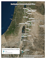
The lab for module 3 focused on creating shapefiles. This was done by either manually creating a point, and creating a shapefile out of it, or by importing a data table into ArcMap. The data table contained fields with site name, site description, and Lat and Long of the site. Once imported and converted into a shapefile, it displayed all the site in the database. When looking at the attached map, Petra site (in blue) is the manually created shapefile. All other sites come from a database that was converted into a shapefile.
In Module 02 we learned to perform SQL queries and to use the Clip tool of ArcMap. In this module we used these techniques to compare the areas and landmarks of Chicago before, and 20 years after the Great Chicago Fire.
The SQL query is a very useful tool for selecting a range of data from a larger database. The query is done by inserting an equation referencing file's attribute table into the tool. Once the query is run, the newly selected data can be exported into a separate shapefile. This provides a quick and relatively easy way to separate a large shapefile into a number of smaller ones that may offer more specific information. In the case of the Chicago Fire map, I have taken a shapefile with landmarks in Chicago, and created two separate file, one with all the landmarks build before the fire, and one with landmarks build between 1871 and 1890.
The Clip tool simply takes a shapefile, and removes all data from it that falls outside of another, related shapefile. In the case of the Chicago Fire map, once I had the pre 1871 landmark file, and 1871-1890 landmark file, I clipped to their respective city shapefiles. The pre 1871 landmarks file was clipped to the Chicago 1869 map, thus removing all landmarks outside the city limits. The 1871-1890 landmark file was clipped to the Chicago 1890 map, again removing all landmarks that fell outside the city limits at the time.


