 In the first part of module 7 we learned to import text and AutoCAD data into ArcMap. This usually involved converting the data into a correct table format, adding appropriate column headings, and assigning projection, if known.
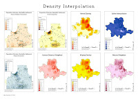
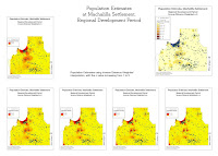
In the second part of the module we learned to interpolate surface data based on known data points. This information can in turn be used to get an idea what the site looked like during the time period we are studying, or to narrow down good places for further studies of the site.
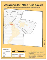 In module 6 we learned to digitize old maps, and linking data tables to the shapefile's attribute table.
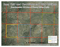 First step in digitizing old maps is to georeference them, which was covered in module 5. The challenge in this exercise was in aligning independent site grids to a separate map showing the grid distribution. The problem was the poor quality of the grid distribution map, and parts of the grid were not visible and I had to interpolate the the full grid. In addition a lot of site grids were difficult to read, as a lot of notes on the maps were difficult to read, either due to poor hand writing or poor scan quality.
The second part of the exercise was to join a data table to the shapefile's attribute table. The challenge here is to create a data table from the old maps and reports that you are digitizing.
In module 5 we learned to georeference images, historic maps in this case. Georeferencing means taking an image such as a historic map, aerial photo, etc., overlaying it on top of an already georeferenced map and adjusting it to correspond with georeferenced points.
Once you acquired a historic map or aerial photo, you need to import it into ArcMap. Also set up a background map to use as a reference. It may be helpful to import an additional background map, either street map or a topo map. This can make georeferencing easier. Then using Georeference Tool, link points on your image to the georeference background. The more linked points the better. These points may be topographical features such as island shores, hills, rivers. They may also be anthropological features: houses, roads, etc. You just need to keep in mind that a lot of these features may have changed over time.


