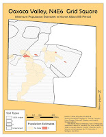
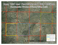
 In module 6 we learned to digitize old maps, and linking data tables to the shapefile's attribute table.
  First step in digitizing old maps is to georeference them, which was covered in module 5. The challenge in this exercise was in aligning independent site grids to a separate map showing the grid distribution. The problem was the poor quality of the grid distribution map, and parts of the grid were not visible and I had to interpolate the the full grid. In addition a lot of site grids were difficult to read, as a lot of notes on the maps were difficult to read, either due to poor hand writing or poor scan quality.
The second part of the exercise was to join a data table to the shapefile's attribute table. The challenge here is to create a data table from the old maps and reports that you are digitizing.


No comments:
Post a Comment