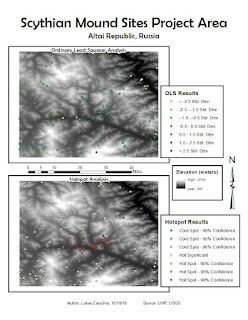
Data presented in this file shows
spatial distribution of known Scythian burial mounds. Data also shows random
points in the project area, and the probability of those points being a burial
mound site. Secondary surfaces generated for analysis were slope, aspect, and
elevation. Slope favored incline of less than 16%, aspect favored south facing
slopes, and elevation favored areas below 2000 meters. Linear regression method
used was Ordinary Least Squares analysis. Missing data includes mound site
distance from the river. Limitation of this model the limited number of points
used for spatial distribution of data.
The OLS
results include the adjusted R-squared value of 0.697804, which means the
variables are explaining about 68% of site presence or absence. The
coefficients are not near zero, and are mostly positive, which means they have
a positive, direct influence on the data. The Spatial Autocorrelation test has
the following z-score and p-value values: z-score of 13.834296 and p-value of
0.00000. The combination of high z-score and low p-value indicates a normal
distribution of the data and spatially autocorrelated data.

No comments:
Post a Comment